ORWA GIS Mapping Assistance
Thanks to funding from the Ohio Water Development Authority, ORWA has utilized the 100+ years of Industry experience of our staff to develop a simple yet robust GIS Mapping template for small public water systems, and are able to disseminate it all across Ohio at no cost to the utilities for the first year. Thanks also to ongoing funding from USDA Rural Development that enables us to employ Circuit Riders to provide Free technical assistance to communities across Ohio, we are also able to provide free on-site training to show system personnel how to utilize their new GIS Maps to improve their asset management programs.
ORWA utilized ESRI’s ArcGIS Online platform.
The main reason we went with ArcGIS was because of the ability to use it in the cloud with applications to collect and update information from the field. System personnel can collect, edit, or delete assets off their map instantly, without any assistance from ORWA. There’s no waiting for weeks or involvement from some other location to add the data to the map. Seeing the fruits of their labor, having the ability to edit data, and creating a map as they work help staff feel accomplished and encourages them to be successful. They know that their work is making a difference and contributing to the future prosperity of their system.
After each map is created, one of ORWA’s Field Technicians visit the system for 1-3 days and provides on-site training on how to add assets, edit them, remove them, etc.
These digital maps empower systems to manage their assets better than they ever have, and the maps become more accurate and more beneficial as they are continually updated and more data is added to them.
Simplistic, yet Robust GIS Mapping Capabilities
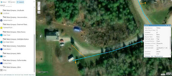
Working with our extremely knowledgeable staff, and recognizing the requirements and goals of an Asset Management Program, we were able to create a GIS Map template that has 19 Different Asset Types and dozens of various fields for each asset.
We made it simple enough that an operator with no experience with GIS mapping could be up and going within a day, yet robust enough that it would allow them to manage their system’s assets better than ever before.
ORWA Map Template Details
- Over 19 Asset Types, including:
- Valves, Hydrants, Water Lines, Line Breaks, Water Towers, Wells, etc.
- Hundreds of custom fill-able fields for each asset, including:
- Diameter, Material, Manufacturer, Condition, Criticality, Location Description, etc.
- The ability to attach:
- Photos, Videos, Receipts, Inspection Reports, Maintenance Records, etc.
- The ability to add “Service Logs” to each individual asset:
- Organized by Date, becoming a running log of any service done to an asset
- The ability to “nest” assets within an asset
- Add your pumps, motors, dehumidified, etc. to your Water Plant and attach photos, receipts, etc. to each of those nested assets
- Real-Time Updates
- As long as you are connected to a wifi or cellular signal, whenever you add an asset, it gets added to your map instantly, and can be viewed from any other computer or devices (if they have your account log-in information).
- Off-line Collection
- If you don’t have access to internet you can simply; download your map prior to leaving the office, collect assets out in the field, and then sync them to your map once you are connected to the internet.
- Video Trainings
- ORWA has developed video training tutorials to reinforce on-site training and allow for training of new personnel
Ready to Get Started?
1) Fill out ORWA’s Assistance Agreement
This is NOT a contract; it is simply a document to explain how the program works, what you can expect from ORWA, and what ORWA will need from your system in order to provide assistance.
2) Submit the completed Assistance Agreement to [email protected]
If you have any questions contact our office.


